We gave a lot of thought what to take and how to pack and were just hoping it would work as we have never done anything like this before.
This kind of travel is filled with adventure and the unknown - so how appropriate, at the start of our journey in front of our flat. to commit ourselves to the keeping of our God. He will keep us from stumbling (Jude), He saved our souls and we know that we can entrust ourselves to His love and care in our travelling.
So off we pull from Ferry Gait Drive via Perth, on the A9, we turn West on the A86 and travel alongside Loch Laggan to Spean Bridge. Turned in at Fort William - looking for a big midge net but no such magic exists. The salesman compared a midge net with a mosquito net and concluded the midges will get through. So we will have to make do with our head-nets. Back to Spean Bridge and turned North on the A82 past Loch Lochie and turned West at Invergarry onto the A87.
Gordon and I walk together along the river Shiel after crossing the old pedestrianstone bridge. When Gordon goes back to Hammy, I hobble over pebbles, find the biggest to sit down on and take boots and socks off. How refreshing the River Shiel is to feet! No towel - but lots of pebbles dry enough to absorb the cold water and rough enough to use as a skin smoother. Cool, bracing and clear-running river. The Dippers are right there and so is the big fat black slug. This does NOT remind us of South Africa but does remind us of the first time we saw these in the Lake District.
The wild Rhodendendrums - and Lupins always catch the eye. Where is Scotland's big melancholy soul? Maybe it is still too picturesque? But already we've had signs of peat and sights of horizontal drizzling - safely inside Hammy listening to "There she was just a walking down the street singing dodidi - etc.!
At Clune we washed our faces in nice clean bathrooms. Clean bathrooms along the way always turned out to be a real treat and so much quicker to get ourselves ready for bed and other necessities.
At the River Shiel we have our first picnic: the low rocks were beautifully placed and spaced and just the right height for us to perch on and on which to pack out our picnic. Our chicken which we stir-fried at home, boiled eggs and tomato and cucumber - eating like Lairds! And Flask Coffee. This was the last time we would have our own coffee on the road as our ancient travel kettle packed up and no matter at how many shops we asked along the way for the next 16 days - there would not be one to be found! We try out the Dunelm pop-out silicon plates and wipe them with serviettes afterwards before rinsing them out properly either later or from water in a bottle.
We stayed on the A87 until we turned off West at the Shiel Bridge onto the steep and zig-zagging unknown minor road for our first sleep over just above Ratagan - a sight-seeing high look-out with some picnic tables.
This was our first try at creating our sleeping space. We put the 2 picnic blankets on the front seats - the food plastic boxes on the passenger seat and 2 small plastic boxes with our toiletries on the floor of the driver's seat. Gordon packed our clothing rucksacks on the back shelf we created with 2 planks under the Hammy luggage cover. We left space for our boots (in plastic packets) and our jackets. The rest of the things we packed on the back shelf above our feet to block the back windows. And the rest of our belongings in the front for the same reason. So when we changed into our pjamas and were ready for sleep the whole area behind the front seats was free and actually quite spacious and definitely comfy.
War Memorial 50 miles from Skye. We had lunch here.
I so loved being with Gordon!
Rhodendendrums and Tree Tunnels
National Emblem
Double Delight
The last of the Gorse
Our first Sleep Over - can't believe the view over Loch Duich!
Chased by the Midges we found ourselves a Eilean Donan in our pjama's
This is what Hammy looks like on the inside
We are here all by ourselves 4.30 in the morning - of course no other tourists around
Iconic
After we tidied up Hammy and changed into our day clothes -
we crossed the bridge into Skye for what turned out to be
We gave a lot of thought what to take and how to pack and were just hoping it would work as we have never done anything like this before.
This kind of travel is filled with adventure and the unknown - so how appropriate, at the start of our journey in front of our flat. to commit ourselves to the keeping of our God. He will keep us from stumbling (Jude), He saved our souls and we know that we can entrust ourselves to His love and care in our travelling.
So off we pull from Ferry Gait Drive via Perth, on the A9, we turn West on the A86 and travel alongside Loch Laggan to Spean Bridge. Turned in at Fort William - looking for a big midge net. No such thing exists. The salesman compared a midge net with a mosquito net and concluded the midges will get through. So we will have to make do with our head-nets. Back to Spean Bridge and turned North on the A82 past Loch Lochie and turned West at Invergarry onto the A87.
Gordon and I walk together along the river Shiel after crossing the old pedestrianstone bridge. When Gordon goes back to Hammy, I hobble over pebbles, find the biggest to sit down on and take boots and socks off. How refreshing the River Shiel is to feet! No towel - but lots of pebbles dry enough to absorb the cold water and rough enough to use as a skin smoother. Cool, bracing and clear-running river. The Dippers are right there and so is the big fat black slug. This does NOT remind us of South Africa but does remind us of the first time we saw these in the Lake District.
The wild Rhodendendrums - and Lupins always catch the eye. Where is Scotland's big melancholy soul? Maybe it is still too picturesque? But already we've had signs of peat and sights of horizontal drizzling - safely inside Hammy listening to "There she was just a walking down the street singing dodidi - etc.!
At Clune we washed our faces in nice clean bathrooms. Clean bathrooms along the way always turned out to be a real treat and so much quicker to get ourselves ready for bed and other necessities.
At River Shiel we have our first picnic: the low rocks were beautifully placed and spaced and just the right height for us to perch on and on which to pack out our picnic. Our chicken which we stir-fried at home, boiled eggs and tomato and cucumber - eating like Lairds! And Flask Coffee. This was the last time we would have our own coffee on the road as our ancient travel kettle packed up and no matter at how many shops we asked along the way for the next 16 days - there would not be one to be found! We try out the Dunelm pop-out silicon plates and wipe them with serviettes afterwards before rinsing them out properly either later or from water in a bottle.
We stayed on the A87 until we turned off West at the Shiel Bridge onto the steep and zig-zagging unknown minor road for our first sleep over just above Ratagan - a sight-seeing high look-out with some picnic tables.
This was our first try at creating our sleeping space. We put the 2 picnic blankets on the front seats - the food plastic boxes on the passenger seat and 2 small plastic boxes with our toiletries on the floor of the driver's seat. Gordon packed our clothing rucksacks on the back shelf we created with 2 planks under the Hammy luggage cover. We left space for our boots (in plastic packets) and our jackets. The rest of the things we packed on the back shelf above our feet to block the back windows. And the rest of our belongings in the front for the same reason. So when we changed into our pjamas and were ready for sleep the whole area behind the front seats was free and actually quite spacious and definitely comfy.
War Memorial 50 miles from Skye. We had lunch here. Tree tunnels.
SLEEP OVER NUMBER 1
Sleep over on a very steep, narrow winding road up, up and suddenly there was this opening. We pulled in to the left corner and could not believe our eyes! To our right was a range of mountains and right in front of us, far down, Loch Duich.
Off the A87 onto an unnamed dead end road - we turned West at Shiel Bridge. To our right some of the munros were Sgurr Na Lapaich (3775') and Riabhachan. (3696") and Ben Attow (3385') and the Five Sisters (3505 is the highest). We just praised our Lord for the stunning view and the combination of munro's and loch. It was exciting to know that the Isle of Skye was not far off. At this spot there is a peacefulnss that can be felt. And - as on most following evenings there was no dramatic sunset just the long gradual change of light of a very late dusk and an early dawn.
Already we are nervous of the midges and make sure we change inside the Hammy and that every window is closed. Are the vents sufficient? We try to open them as wide as possible without giving the midge an entrance.
How exciting! We got an sms from Isabelle but no matter how hard Gordon tries to reply straight away the only signal he gets is an S.OS signal. We are amazingly comfy in the back. Gordon has even a little length to spare. Hammy's width gives us enough space. The birds are singing their little hearts out!
We decide not to use a divider in the front and feel sufficiently private with our semi-tinted side-windows plus black pull-up screen. It is a strange feeling to lie in the back of a long car, but amazingly comfortable! It is raining outside, inside we feel secure and cosy and thankful! We were surprised that it was so warm and had to the hunt for the sleeping bag liners. We would still have to find ONE place for our things. Very much still at experimental stage. This is only our first night on the road, car-camping!
Our bedding was planned in such a way that we should be okay in all temperatures. A liner if it's hot, using the sleeping bag as a blanket, using the sleeping bag and duvet to warm us up plus liner. It turned out that we mostly needed either just the liner or just the sleeping bags as blankets. But then it's summer in Scotland and we don't even want to THINK what it would be like in winter time and during long, long nights!
FRIDAY 6TH JUNE 2014
SLEPT ON ELGO ROAD IN THE EVENING
Road to Armadale:
Skye and the Torskavaig Road
Heading further down the road towards Armadale you pass the Isle Ornsey and its light house. On the other side of the Sound of Sleet is the entrance to Loch Hourn. Beinn Sgritheall is the mountain that dominates the horizon.
However there is a single track road that runs the length of the Armadale peninsula on its west side and I had more luck on that route. It offers great views towards the Cuillin hills and Bla Bheinn.Its a very narrow twisting road that has some very steep gradients on it so its really only suitable for smaller vehicles, but the views are great.
Looking across Torskavaig Bay towards the Black Cuillin of Skye.
Bla Bheinn from the village of Ord
ELGOL Its a small fishing hamlet complete with pier at the entrance to Loch Scavaig. Photographers come from all over the UK to try to capture the Black Cuillin vista as the sun sets. The interesting and varied rock formations on the shore add foreground interest and no two nights ever look the same due to the different cloud formations over the mountains and the lighting effects caused by the disappearing sun. I too have stood shoulder to shoulder with the rest of the snappers, snapping frantically until it is too dark to see the sea.
your attention is drawn across the loch to the towering bulk of Bla Bheinn, or Blaven.
This magnificent mountain is an outlier of the Black Cuillin. It is sometimes climbed from the west side of Loch Slapin: but while it is much more approachable than any of the peaks on the main Cuillin Ridge, it is still a climb only for the experienced and well prepared.
The road to Elgol rounds the end of Loch Slapin, then follows its edge south, past the many fishing vessels moored in the loch's sheltered northern reaches at Faoilean.
Then the road climbs above Loch Slapin before crossing the Strathaird peninsula. As you near the top of the climb watch out for the rough land rover track heading west from the road (the parking area opposite is the most obvious sign of its location). This leads to Camasunary, the tiny settlement that provides a gateway into a large part of the Cuillin, and the start of another route up Bla Bheinn.
For those who like the idea of leaving the car behind, a walk of just over a mile and a half along this track, involving a climb of around 500ft, brings you to what is possibly the best viewpoint in Scotland, with a vista that sweeps round from the Isle of Rum to take in the main Cuillin Ridge and Bla Bheinn. View a 3200x600 pixel panorama taken from this spot here.
Having crossed Strathaird you descend steeply into Elgol. This is a dispersed settlement sprinkled over the hillside above the jetty and the nearby moorings. To the north is a beach of large pebbles that leads the eye past a large outcrop of rock and across Loch Scavaig to the mouth of the Cuillin. The Cuillin inspire awe whenever you see them, and never more than when you see them from Elgol.
And when you are in Elgol you can do more than just view the Cuillin from a distance. From here you can gain access to the very heart of the mountains without having to walk miles across rough and boggy country, or climb over the Cuillin ridge.
Because for centuries it has been the norm for visitors to be taken by boat right into the heart of the Cuillin. Since the early 1990s, Bella Jane Boat Trips have being doing just that: running visitors to and from the head of Loch Scavaig, from where it is a simple walk of a quarter of a mile to Loch Coruisk.
Nowadays, visitors also have the option of the similar service offered by Misty Isle Boat Trips. And those looking to go further afield could do worse than check out Aquaexplore's use of a powerful Rigid Inflatable Boat to allow trips to destinations as distant as Canna, Rum, Soay, and Eigg.
While in Elgol it is worth taking the minor road that runs for a mile and a half over Strathaird to the crofting settlement at Glasnakille: with its excellent views south east towards Tarskavaig and the Sleat Peninsula. And on your return (for it is an out-and-back trip), the Cuillin View Coffee Shop in the upper part of Elgol is also well worth exploring.
Well Worth the Drive!
Though you may never have heard of the little fishing and crofting village of Elgol in the Scottish Highlands, there is a good chance that you have seen photos of Elgol's famous mountain and seascape scenery in postcards, Scottish books and even film scenes and television programmes. From the larger Skye village of Broadford many visitors have turned down the enchanting Elgol road completely unaware of the magnificent scenes that await them around almost every corner. The 15 mile journey over twisty single-track roads will take you past High Pastures Cave, one of the most significant archaeological finds in the area, then sweep you around the corner to the ancient, historical site of Kilchrist church.
You will carry on (being careful of the sheep and Highland cows that roam freely on and off the road!) through Torrin where you will be greeted with a famous postcard view of Blaven, one of the best known mountains of the Cuillins. As you continue to drive around Loch Slapin where the local fishing boats anchor for shelter, beneath the shadow of Blaven, you will eventually rise over a little hill to catch your first glimpse of the sea and the islands that lie off Skye.
Elgol Village & the Mackinnons
Every mile you drive on your journey from Broadford to Elgol will fool you into thinking that the scenery simply cannot be bettered. However, you will be proved wrong when you arrive in Elgol and reach the shore and the little fishing harbour. There is simply nothing on earth to compare to the site of the Cuillin Hills beyond the Elgol shore - a breathtaking view whether it is sunny or stormy.
There are various opinions as to the meaning of the name, 'Elgol' (or Ealaghol in the native Gaelic, some suggesting 'The Noble Dale' and others 'The Weeping Swan' (folklore details the story of a Viking captain who perished when his longboat named 'The Swan' came to attack the people of Elgol). Chris & Fiona MacKinnon, the owners of Cnoc na Loch holiday cottage in Elgol are local to the village with Chris' family having lived in Elgol for generations.
Elgol is certainly a village of 'MacKinnons'! The parish of Strath in which Elgol is situated has been a MacKinnon stronghold for hundreds of years. The story of John MacKinnon ferrying Bonnie Prince Charlie to safety in a cave on Elgol's coast in July 1746 is famous worldwide, and John MacKinnon's descendent, Seumas MacKinnon, follows in his ancestors' footsteps still as he ferries visitors from Elgol to Loch Coruisk, set in the heart of the Cuillin Hills, in his boat, the Misty Isle.
Panorama taken from the hills overlooking Elgol and Loch Scavaig on Skye. This picture was taken on a sunny afternoon in May 2009.
Elgol - Skye visitor guide showing a virtual tour of 'Elgol' linked to an interactive map with local and travel information. 360° panoramas from Highland.
Elgol lies at the end of the road on eastern side of the Strahaird Peninsula overlooking Loch Scavaig on the Isle of Skye in Scotland. Tradition states that the name came from 'Aella-gol' after a naval conflict involving the Vortigern ship Aella against 5 other ships of the Picts and Scots in the 5th century.
Elgol and the Strathaird Peninsula was a stronghold of the Mackinnon Clan, a strong Jacobite Family. Charles Edward Stuart (Young Pretender of Bonnie Prince Charlie fame) sought refuge in Elgol during his flight to France in 1746. Just south of Elgol is 'Uamh Phrionnsa' cave (Prince Charlie's cave) where it is said that Charles hid for a time. It is not the only cave on Skye claiming this.
Elgol and Strathaird suffered greatly during the Clearances, which greatly reduced the population of the village. Set in a remote part of Skye with stunning views over Loch Scavaig to the mouth of the Cuillin, home to many Munros on Skye, the village has become popular with visitors, and many of the homes are now holiday homes. The area offers stunning sunsets with views over the islands of Soay and Rum. Just north of Elgol is Ben Cleat (277m) which offers spectacular panoramic views of the surrounding area.
Bella Jane Boat Trips run trips from Elgol to the head of Loch Scavaig, a short distance from Loch Coruisk and the heart of the Black Cuillin. Trips are also offered by Misty Isle Boat Trips. Both these companies offer a number of tours around the area, visiting seal colonies and viewing other wildlife. Aquaexplore run boat trips to Canna, Rum, Soay, and Eigg.
The coastline around Elgol is rich in fossils, with some layers of rock particularly rich in bivalve mollusc fossils. Belemnites and ammonites can also be found here in rocks along the foreshore.
TRAVEL DIRECTIONS AND GETTING THERE
Elgol is about 14 miles south of Broadford on the B8083 road. The road passes through numerous small hamlets including Swordale and Torrin before looping round Loch Slapin and then along and over the Strathaird Peninsula to Elgol. On the way the road passes a chambered cairn and the ruins of Cill Chriosd church.
30 miles of minor road from Broadford to Elgol and back provides a varied route to one of the best viewpoints in the whole of Britain.
From the car park in the centre of Broadford take the A87 north for 100m before turning left onto the B8083 signposted to Elgol. From here it's impossible to go wrong as there's only the one road with no further junctions! After leaving Broadford the road climbs slightly then undulates for a numberr of miles, passing Loch Cille Chroisd before reaching the scattered village of Torrin. There are spectacular views of Bla Bheinn across Loch Slapin before the route swings round the head of the loch and follows the west shore below Bla Bheinn itself. After the road leaves the loch-side things get more difficult with a 90m climb then descent to Kilmarie preceding an even larger climb to Elgol itself. the route finishes with a steep descent to the pier at Elgol from where there are spectacular views towards the Cuillin mountains. The return is by the outward route, but if time allows the boat trip to Coruisk in the heart of the Cuillin makes this into a very worthwhile full day outing.
The names along the way tell their own stories. Am Bastier: "the executioner"; Sgurr a Ghreadaich: "the peak of torment"; An Garbh-choire: "the wild cauldron".Broadford, Sleat & Southern Skye
The Skye Bridge and both the ferry links bring visitors into this "first impression" of Skye. While all of Skye is a visual delight, the Sleat peninsula is sometimes described as the garden of Skye, with its woodland and pasture adding a softer aspect to the island.
Towards the southern end of Sleat, Armadale Castle and the Museum of the Isles tells the story of the powerful Clan Donald. There is also an attractive garden and nature trails here.
Both Sleat and Strathaird are easily reached from Broadford. This community, a well-resourced village with a range of craft outlets and shops, is strung out along the shore and looks over to the Applecross peninsula. Broadford can also be easily reached from Kylerhea with an added attraction on this route being the Otter Haven near Kylerhea where a carpark and short walk lead to a Forestry Commission otter viewing hide. (Otters are thriving in many parts of Skye and Lochalsh - and the sea-lochs and sheltered waters are also excellent for spotting whales and dolphins.)
The road to Elgol is a must for every Skye visitor. At the little village of Elgol is what has been described as the finest view in Britain - the end of the Cuillin ridge seen across Loch Scavaig.
Boat trips from Elgol go for a close-up view or there is a vertigo-inducing path north from Elgol itself. On the way to Elgol there is another classic Skye view, this time of Blaven, a jagged Cuillin outlier, from across Loch Slapin.
Note, on the way, how the black gabbro rock of the spiky Cuillin Hills (the Black Cuillin) contrasts with the pinky-red granite of the more rounded Red Hills (or Red Cuillin) which come into view towards Torrin on the Elgol road and, from another angle, by the A87 beyond Broadford
Below are just a few of my attempts at trying to capture the feeling of looking towards the dark hills of Mordor as Sauron and the Nazgul search in vain for the ring.
We wake up early morning in this idyllic place - STRESSED BY THE MIDGES. We are besieged, surrounded and enveloped. We see them through Hammy's windows, and some were inside! Let's get out of here!- must get out of here - NOW!! Where are the smidge and Avon and nets - can't find them nor the keys immediately. It would take a day or so to get used to where what is kept. We find the defence weaponry, climbed through from the middle to the front and I stayed in the middle frantically rubbing all the different midge stuff we have - putting on midge net - not Gordon while driving away as soon as possible.
We move the luggage from the driver's seat at super speed. Gordon, still in payjama's that don't look like pajama's jumps in the front and pull off. We know that a midge is no match for movement faster than 5 kph. We pick up as much speed as we can winding down the narrow road with sharp bends, and once up to speed opened the windows wide and turned the heater on full blast - to blast the midges. I try to take pics from the wide open windows of the woods. The hope is that the little pests would get blown out and far, far away from us, fried to a frizzle before they do anymore damage. I'm in the middle in my pajamas that don't look like pajama's, trying to shoo them out of the windows. Imagine if midges buzzed
We get to the bottom of the road and suddenly and surprisingly find ourselves at what is claimed to be the most photographed castle in Scotland. We feel quite unkempt and slightly flustered but greatly relieved to have shaken off the plague (for now!). The 1210 Eileen Donan castle is so impressive! Just us there - and one photographer at 5.30 am att one of the most recognised and one of the most iconic Scottish monuments - in our pyjamas!
At least this popular visitor attraction opens at 10 am and here we are, chased by the midges, at 5.30 am! What a setting - on its own little island overlooking the Isle of Skye at the point where 3 great sea-lochs meet - Duich, Alsh and loch Long. The setting is surrounded by forested mountains of Kintail. (We car-camped next to the forest which was nice midge-land).
Bishop Donan had an eye for a setting when he chose this spot back in 634AD to create a monastic cell. Lots of changes through the centuries from a cell to a castle which was bombarded from 3 heavily armed warships with a canon in 1719. Was it any worse than midge attack - or did the Scots think of letting lose a midge army? Apparently not, because on that day poor Eilean Donan lay in silent ruin for the best part of the next 200 years.
We are so privileged to have Scottish Heritage cards, it was possible for us to cross the foot bridge and at no further cost wander around the fab rooms, checking out period furniture, weapons and fine art and spying through spy holes and walking around in the banqueting room, but it was not to be, because:
1) We were here - in our pyjamas at 5.30 AM! and thought to wait 4.5 hrs for the castle doors to swing open was a bit too long, and
2) after our Skye-adventure, we past right by the castle that appears on many a fudge and short bread tin and fridge magnet - well after closing time.
Here is where we parked Hammy and for the first time lay on our backs in the back - changing into day-clothes!
This in an internet picture. Right now we are downloading and clearing memory cards and will post our own pics.
In future, if there's no breeze we would not park near a forest again - that's for sure!
We are in bed early most evenings - early as in between 8pm and 9pm - despite the strong delight.
We usually chatted about the day, jotted down some diary-points and then read together from 1 Samuel. Skye Bridge. First to Broadford - chemist. You have a bad reaction - anti-histamine - knocked out for 2 hours in the car, I just couldn't keep my eyes open. That's it no more histamine during the day! Gordon is a bit nervous that this medicine would clash with his heart tablets, but later on found it's okay. We are both covered in bumps and very itchy! At Broadford went to wash a few things, but made a mistake! First did the food-shopping - then went back with a shopping bag and in it our few bits and pieces of washing and some soap. The restrooms were inside the shop part of the shop. What when I walked out with the wet washing and if they thought the shop-lifter's shopping bag needs inspection???!! At Armadale - we watch the ferry and trying to work out where Malaig is on mainland Scotland.Today we arbed around at the foot of the Cuillens on a bright sunny day so we see them in all their glory, crags and shapes. Gordon finds no eggs in a box next to an honesty box. Watched the ferry. Sat like dassies in the sun at the Shed sharing a fish pizza watching the blue heron. At Armadale we wash our hair in the private loo. Feel a bit awkward emerging with wet hair. It takes an age to rinse - next time I used a bottle to fill and pour warm water over my hair - much quicker! Winding around the Isle of Skye on twisty roads. We see the craggy black and bald Coullins with their jagged rock formations again and again from different angles.
We woke up at 8 am to blue skies. We hang out our drying socks and undies and feel completely accepted by the sheep families. The odd car whizzes past and the sheep trot past leisurely.
Slept on the road to Elgol.
We wake up in the night - needing air and opened all the windows. Soothing rain outside. We went to sleep and woke up surrounded by the Coullins - no cover by a cloud!
Elgol pier.
We listen to Friday Night is Music Night at the foot of the dramatic Cuillens and remembered the concerts we used to go to of live recordings of Friday Night is Music Night. Nice to listen to the radio! We bless the strongish breeze; both because it is cooling us off in our 20 degrees and of course - making it uncomfortable for the midges. No trees - just the absolutely perfect spot.
SATURDAY 7TH JUNE 2014
SLEPT OVERLOOKING DUNVEGAN THIS NIGHT
Woke up on the Road to Elgol - sliding the door and gazing at the mountains - every crag and ragged shape in the soft morning light.. A real answer to prayer! What a sight from our bed. Pink clouds on the one side and yellow clouds on the other. Lying in our Hammy bed seeing the change of the colour of the clouds which are not hiding a thing of the mountains. Totally relaxed.
Walk to the Fairy Pools - people picnicking and dipping in and out of the pools. I take off my shoes and oh how refreshing to dip them right into a small waterfall. I feel a bit whoozy with the anti-histamine - not a good thing walking right to the edge of the top of a waterfall.
Just as we packed everything, and settled into our Hammy-bed it starts to rain. This is the kind of blessing we counted. We didn't at first realise we have a lovely view on Dunvegan. Hahaha we were contemplating sneaking into the Castle grounds but after having a drive around the grounds we discovered all the gates have locks - oh well!!
At foot of the Black Cuillins near Glenbrittle are the Fairy Pools, beautifully crystal clear blue pools on the River Brittle. These famous pools entice visitors from all over the world, as they make some great ‘Wild Swimming’ for those brave enough to enter the cold water. For the less adventurous these magical Fairy Pools make some fantastic photos.
The walk to the pools uses the same route there and back. The complete return distance to the first main waterfall and pool is 2.4km, with the average time to complete the walk being 40 minutes (with no stops). Most people will spend some time working their way up the river from the first waterfall exploring the different pools.
We have classed this walk as ‘Short’ in length and ‘Medium’ for difficulty, check the rating guide for details.
Location
The nearest village to the Fairy Pools is Carbost on the West of Skye, the start of the walk is on the road to Glenbrittle.
Weather
This walk is suitable in most normal weather conditions, but if it has been raining hard some on the river crossings can become a real challenge.
Parking
Park in the Forestry Commision gravel carpark signposted ‘Glumagan Na Sithichean’ (below in smaller writing it does also say Fairy Pools).
It is located along the single track road that leads to Glenbrittle from Carbost. The carpark is 5.5miles (10 minute drive) from Carbost. If traveling from Portree it is 20.5miles and will take about 30 minutes to drive.
The Walk
From the carpark there are impressive views out towards the Black Cuillins, the source of the River Brittle. This short walk to the pools follows a gravel path that is in good condition most of the way, but does involve river crossings over stepping stones. It takes about 20 minutes to get the first and largest waterfall that marks the start of the pools.
Make sure your look through the Walk SlideShow, as it give a step by step account of what you will encounter.
Stage 1
From the carpark cross the public road to find the start of the path. There is a small green sign confirming the start, labelled ‘Sligaghan’.
As the path leaves the road it is steep and rough, don’t be put off by this as the first few meters are about the worst.
The gravel path drops gently downhill. On a wet day can be muddy in places.
After about 50 meters from the road the path splits, take the right hand option and continue down the hill.
After a short while you will reach the first river crossing where there are large stepping stone to cross.
This crossing is typical of the other crossing ahead.
Once across follow the gravel path.
Stage 2
The path is now level and crosses a peat moor with Heather and Grasses.
Ahead you will see impressive large rock boulder that seem almost random location, but was left as the ice melted are the end of the last ‘ice age’.
The path gently raises and meets up with the main River Brittle. Which will now remain on your right hand side as the walk continues.
There are regular small crossing a steams and ditched, but nothing challenging.
Stage 3
You will now reach the second river crossing and again there are large stepping stone. This river can get very full on a wet day making a difficult crossing.
After the river the path rises up with some rough rock natural steps.
The first Waterfall will now come in to view.
Follow the gravel path on until you become adjacent to the fall.
The Fairy Pools
This first Waterfall marks the start of the magical pools. Take some time to work your way up the river and explore all the pools. Some of the pools make great swimming, but rarely get warm (a wetsuit is a good option).
This first waterfall is the highest fall and deepest pool. For the brave only there are some great high jumps. On the other side of the river from the path it is possible to jump into deep blue pool (approximately 10 meters high).
Follow the main path up beside the river to find more pools.
The next pool up is properly the most famous, a beautifully clear blue pool idea for swimming. It features a natural arch, offering an exhilarating under water swim though the arch.
There many small pools as you work your way up the river.
Stage 4
The return; use the same path back. From the first waterfall it takes about 20 minutes to get back to the carpark.
Praying for an overnight spot became a regular request and sometimes a plea! We gave ourselves an hour to look and we learn that wheelie bins are a sure sign that there's an entrance to a property. A cattle grid gate often has possibilities, but mostly our strategy consisted of going on minor roads and it was just a matter of looking and looking till we found just the right spot and we say - "this is it!" In this kind of search the extremely long days are a real help and blessing! This evening one of our hunting spots was a small working harbour, but it looked just a bit too rough and knew the fishermen would probably be busy early in the morning.
Listening and sharing the ipod: each with an ear-pod. Wow the back of the front seat makes a real good head board! Surrounded by sheep grazing while the light lasts.
Sleep over at the cemetry - Quiraing. Walkers early in the morning. We believe in the resurrection not in ghosts. Above us towers the Quirang. Gordon - ever the practical thinker - reckons we need to tell the children that our Hammy would be just the right size to use as a hearse. We have already proved that we fit in just comfortably!
Today we spent a long long time on a beach - just resting, walking, watching diving terns, cheeping oyster catchers and little ocean birds trying to distract us. Fall asleep with a view over the beach and the mountains. Wow it was hot today! We eat our cereal with a view next to none!.
Sleep at view over Dunvegan
SUNDAY 8TH JUNE 2014
SLEPT OVER AT QUIRANG AND CEMETRY THIS EVENING
Wake up with midges at Dunvegan Castle.
We walked to the Coral Beaches very very early in the morning. The sheep graze right next to us - woken by their munching! Quite lovely to stroll out at 4.30 am!
This is an essential walk for any photographer as it passes though some of the most spectacular landscapes in Scotland. As part of the Trotternish ridge it has been formed by a massive landslip which has created high cliffs, hidden plateaus and pinnacles of rock. Choose a clear day and bring your camera.
The Quiraing walk is a loop, returning you to the same point (the carpark). It covers a distance of 6.8km, with the average time to complete the walk being 2 hours (with no stops).
We have classed this walk as ‘Medium’ in length and ‘Hard’ for difficulty, check the rating guide for details.
Location
The Quiraing is situated in the north of Skye in the area known as ‘Trotternish’. The start of the walk is accessed from either of the villages of Staffin or Uig, which are joined by a single track road.
Weather
This walk is not suitable in all weather conditions. As it take you near high cliffs so it cannot be recommended in windy conditions or if it’s misty (low visibility).
Parking
The carpark is located at the highest part of the single track road 5.5miles from Uig or 2.5miles from Staffin. If traveling from Portree it is 21miles and will take about 30 minutes to drive.
The carpark is not that big so fills up quickly mid-summer, you may need to drive further along the road to find a spot.
The Walk
From the very start you will realise you’re in for something special, as from the carpark you can see impressive views looking north at the ‘Prison’ and the high cliff faces.
Make sure your look through the Walk SlideShow, as it give a step by step account of what you will encounter.
Stage 1
Follow the path that leads north from the carpark, the path is rough under foot with steep grassy slopes on your right hand side.
As you look ahead you will see high cliffs & to the right a rock structure which is known as the Prison. From particular directions is looks like the fortress walls of an ancient Prison.
After about 10mins you will reach one of the more challenging parts that involves scrambling over a rock gorge to cross a small stream. Check the Photo Slideshow – (It is possible to navigate around this by leaving the path and heading lower down the grassy slope)
After a careful crossing the path leads on towards the Prison and then passes between the Prison and the high cliffs. By the prison you must ascend up a bank of scree (lose gravel).
With the Prison on your right hand side if you look left you will now see some very large rock columns the largest it known as the ‘Needle’.
Just after passing both the Prison and the Needle you will come to a wire fence with a stile to cross.
Stage 2
Follow the path with the cliff face on your left hand side and a steep grass slope dropping down to your right.
You will start to see more rock structure in the distance and the path will drop down in to a shallow valley. The path will divide into two and is marked by a pile of rocks (see Slide Show), take the left option to keep the main cliff face on your left.
The route rises up and ahead you will see a stone wall. Cross the Wall and you will find yourself in and other small valley. The path becomes rather muddy.
With more rock structure ahead the path climbs up to eventually meet another wire fence with a simple stile to cross. This marks the half-way point.
Stage 3
From the fence take a hard left turn to head upwards following the cliff top. As you progress upwards at times you will be very close to the cliff edge with some huge drops (Be Careful).
The views are also huge, so take breaks to get your camera out. As you look out East you can see the village of Staffin below then the Islands of Raasay, Rona and then beyond the hills of Torridon on the Mainland.
Work your way up the slope, at times the path can be wet and muddy. The worn route becomes a ladder of turf footsteps (an interesting path).
When you get to the summit at 540m carefully look down from the cliff top to be rewarded with the spectacular landscape of the ‘Table’, a flat glassy plateau surrounded by rock formations and cliff faces.
It has been said that hundreds of years ago the Table was used by locals to hide sheep and cattle from invaders, as this hidden plateau cannot be seen from lower down.
The Table can be accessed, but does involve a scramble, so is not recommended of the average walker.
Stage 4
From the summit follow the path down, the main route does move away from the cliff top. If you would prefer to continue down following the cliff top (better views) then eventually that route will link back up with the main path.
There is a wire fence on the way down with a metal Gate. The path then traverses a steep grass slope, at times becoming wet and muddy.
Looking downhill you can now make out the carpark. As you continue back and downhill the path become steeper & rough.
After heading downhill the path links back with the original trail taking you back to the carpark.
Ready for sleep at 8.35 pm! We are getting more organised and at night have our hanging torches at hand, midge nets, car keys and rain-gear. Tonight we are wearing midge-nets! Once again - as at most other times, no signal.
Kilt Rock - 2 Swiss Christians. Kilt Rock was an anti-climax. The cliffs at 200' tall with vertical lava columns..
My scary grassy cliff climb.
Sleep at Cemetry at feet of Quiraing surrounded by mountains. Here people grieved for their loved ones, here tears fell. Death is the enemy Jesus overcame. Even if you die, you will live.
We read 1 Samuel about God's gentle patience with Samuel when His calling almost looked as if it wasn't going to succeed!. We are midge-aware.
MONDAY 9TH JUNE 2014
SLEPT OVER PORTREE CAMPSITE THIS EVENING
Good weather.
Woke up next to cemetry at Quairaing
On the way to Portree. Shortly after Stromeferry. We drive along a wooded pass and have beautiful glimpses of (sea lochs). At Stromeferry we have a medley of fish, roast chicken, shop cole slaw, naartjies (nectarines) and pop cherry tomatoes.
Portree campsite. It's a rest day for us Torvaig campsite. T
Doing washing here - wonderful shower! The camp-woman swore badly at me for putting the coin in the wrong slot. I'm glad to be wearing a midge net and she cannot see either my face or expression. Had to talk to myself to say nicely to her that instructions would help. She was wearing her midge net too.......maybe that added to her irritation?! In contrast to this rude treatment was the wonderfully kind people we met everywhere and we would put right at the top the Thurso soup - but that's for another day!
Our water absorbent towels work beautifully. One of my old sarongs (a tip we used when camping around Europe for 2 weeks). It's both absorbent and quick-drying. That's one thing we are glad we didn't cart along: towels! Two face-cloths was the limit we went to. It worked quite well slipping into a small plastic bag and into a pocket to use as a face wash or even more than that at bathroom somewhere.
Gordon strung up our stretch-washing line with the 2 plastic coated hooks right around behind the front seats. This served beautifully for small washed items like underclothes, socks and later we hooked our glasses, our lights and the car-keys over them.
Slept at Portree campsite
Lots of people buying ice-cream it is very very hot!
TUESDAY 10TH JUNE 2014
Wake up at Portree Campsite late! Downloading photos at Portree. The library staff are lovely and give us a table and a spot and most importantly a plug which we can use to download some of the memory cards. We have not yet found out that we can do 7 nights on a trot and more. It is quite rainy. Read and noted a truly funny book on a senior bus pass traveller! Interesting chats in the library about midges and bonnie places in Scotland: fingers tracing the map. We are starting to have second thoughts about travelling all the way to North Scotland. We agreed to wait and ask for guidance and we feel sure that we will know when we get to the cross-roads of going North or South. And so it turned out to be and we have no regrets for continuing North - at all! Gordon, on advice of the camp-lady went to the garden centre and priced midge nets that give covering from head to middle including arms - at £22! Tempting....but survived to tell the tale we survived without them.SLEPT THIS EVENING LOCH CARRON
WEDNESDAY 11TH JUNE 2014
Woke up at Loch Carron
Apple Crossing.Was it the cattle pass today? What an experience!!! And even more so for the cyclists who laboured up including a woman who is 23 weeks pregnant. At the top we chat to and admire the guys who made it and I walk a little distance away to go and put a rock on a cairn for them and also to remember 1998 when we did the same thing in the same strong wind at the top of the world. Gordon placed his stone on the cairn with: "Scotland the Brave!" Mheanbh-chuileagan.Wester Ross is where our eyes are resting.
Gordon and I lost each other here somewhere.high high up - sharing our spot with sheep. overlooking the Minch. Saw a submarine - at first thought it was a whale's tail. Lots of sheep-dung.
We slept over at the cattle grid - was it at Loch Torrindon? Love it when the sun is shining and there's no hint of a drop of rain, to shake out our sleeping bags and hang them over the Hammy door for a good bit so sunshine and mountain and highland freshness.
We made it our business to go to bed every night as clean as possible!! We changed into fresh clothing before sleep-time and before putting the wet-wipes with their clean smells to work. Cattle Grid - just hope the farmer has no plans to move his highland coos and tomorrow morning. As for the sheep: the hills and cliffs and open land - these are theirs for the roaming: their oyster! Today we crawled up and down passes - the high-up and down blind corners can be a bit stressy! Sometimes the strip of tar was literally the width of a car with no room for leaving it on either side. At least it's tarred and the other big plus is the passing places! It becomes second nature to make a mental note where the last one is wincing at the idea of reversing back with no room to spare. Shigain Island? We know the seals are playing there - but did we see any? Nope! Wester Ross is a beaut! Always in sight - especially in the good weather we are having - are the Isles of Skye, Raasay and Rona. We are dependent on the map for place-names that we've never heard of before and sometimes don't know how to pronounce. Every now and again we hear folks chatting in Gaelic and the plea for the yes-vote can be seen in fields and against rock-faces - here and there. The binoculars were FANTASTIC!! Gordon was trying to see white-tailed eagles and other times we were really surprised how well it works even to see things like a submarine from one of our sleep-over spots and caves on the side of a cliff head. Here today we saw a hillside absolutely covered in rhodendendrums. Went there for a walk - should have taken the midge net! There is a big tug of war in my heart between the beauty of the wild Rhodendendrum covered hill-side and valley - and the relentless beasties. We had more than a whiff that this could happen - and still are convinced that Scotland's beauty outweighs the midge. But it could drive you dilly! We quickly learn with gratitude that we can cope to get ourselves sorted for the night in the rain - without having to get out of the Hammy. It does take a bit of contortion, a lot of doing things in the right order. We are feeling a lot more at home on the road! Midges are funny - you arrive somewhere and all in the world is fine without them and suddenly out of the blue there the midge-cloud is all around you! Do they have a secret code of telling one another where there's human blood? The tiny fly has a wingspan of 1.4 mm and up they rise from (?) to bite, torment and suck. Midges by the dozens - surely there are more - around your head, biting. You swot and kill - maybe 2! There's a Raasay saying: "kill a midge and a 100 come to the funeral" Gordon has just counted 68 bites on one forarm. You swot at a cloud of them hanging about your head; you flail and claw at your scalp where they have landed and punctured you. They thrive in places with a rainfall higher than 50 inches per year. In 19-something Lochaber had 220 inches of rain - midge paradise! If only they were prone to drowning. One local told us that the smidge only drowns the females in search of blood-meals to fertilise 80 eggs per midge. Not a nice thought to find out that the midge bite is produced when the mouth part is used with a scissor-like movement to rasp (rather than pierce) the skin. And lo and behold - the more bites you have the more you attract the midges. The Inner Side of Raamsay. Tonight we take our time to prepare food and eat in a relaxing way. Today we got chocolates to munch on and biscuits for tea. Well not really for tea - as the best we can and want to do being the kettle-less travellers is to get a £1 or £1.25 Latte or something like that and share a big take-away cup from a Co-op grocery store or the like. Wow some shops are minute!!! Oh just remembered - we stopped at this place just in time BEFORE load of tourists arrived. We shared a bowl of soup and watched 4 of the staff waiting at the door to give the weary travellers a lovely welcome and making them at home. That is the very reason people get into the Lonely Planet guide books! We are now timing our car-camping around midges' favourite times and spots. Today we clapped eyes on abundant natural creation around every corner.
Sleep over at the Cattle Grid (near Torrinden). Every car - few and far between - do make their presence known with their rattle over the grid. Lower Inveralligin. Diabaig
Cattle Grid
INTRODUCING TWO LOCHS RADIO Hosts, and beneficiaries, of the 16 July ceilidh is Two Lochs Radio, Britain's smallest commercial radio station which broadcasts to the communities in the Gairloch and Loch Ewe areas on 106 and 106.6 FM. It started in 2004, and now broadcasts seven days a week with more than 50 hours of programmes a week. Of these, more than 20 hours are live programmes, in which local news, weather, What's On and interviews feature strongly, along with a mix of music. The remaining 30 hours consist of pre-recorded programmes, mostly generated by residents from the Two Lochs area, and range from music to features.
The radio station is manned by volunteers apart from a part-time station manager. Even so, it costs more than £500 a week to keep Two Lochs Radio on the air. While advertising and sponsorship pay a signficant part of the running costs, the radio station continually needs to raise funds to help meeting the running costs. In addition, the station is currently working towards improving reception for residents in a number of "blackspots" where the signal is poor, and extending coverage to the Loch Torridon, Gruinard and Achnasheen areas. And also, after 10 years of daily use, some of the studio equipment and computers are showing signs of wearing and need replacing.
So come to this week's ceilidh and support our community station Two Lochs Radio, keeping you in touch! DIABGAIG
THURSDAY 12TH JUNE 2014
Wake up at Cattle Grid DIABAIG Deee ya beg!!
The road to (and from) Lower Diabaig from Torridon is a winding climb through moors and lochans, passing above and around the villages of Inveralligin and Alligin Shuas, before climbing steeply and dramatically inland to cross the Bealach na Gaoithe, beyond which youpass, probably without noticing them, the few buildings comprising Upper Diabaig. Here you will cross the Bealach na Gaoithe, with super views over Upper Loch Torridon towards Ben Damph and Coulin Forests. It comprises a number of houses strung out along the road as it descends steeply, via a hairpin bend, to a pier on the shore of Loch Diabaig, an offshoot of Loch Torridon.
There are no shops or tourist facilities here, and the only visible commerce is the fish farm run from a white building not far from the pier. Lower Diabaig, with rough and rocky terrain, has its own allure. The road rises steeply. To the north and north west the setting is more pastoral, but the land still rises very steeply.
But the details you see in Lower Diabaig also add to the attraction. The red telephone box next to the white building adds a "Local Hero" feel, while the large abandoned fishing vessel at the west end of the shingle beach is an obvious focal point. And the pier is fascinating, and still used by occasional smallfishing boats.
There are a lot of dead end single track roads in Scotland leading to a wee settlement, a lighthouse, a beach, a ferry terminal, etc. These roads are often overlooked by visitors because they are basically going nowhere, well almost that is. These are the roads I liketo follow, I want to see what's at the end of a particular road because I know there is often something extraordinary to find. From all these wee single track roads I've followed I can safely say that the Torridon to Diabaig road is an exceptionally beautiful one. For many visitors Torridon and Shieldaig inWester Ross are the main destinations, going even further doesn’t fit in their time schedule because of the planned circular tour people make. For more remoteness turn off onto the dead-end roads.
single track road leading to Lower Diabaig and it happens to start in the lovely village of Torridon. Now don't be fooled by this nice village situated on the shore of Upper Loch Torridon.
The single track road from Torridon to Lower Diabaig is only 9 miles but there is something beautiful around every corner. This road offers some of the most stunning views over the Wester Ross hills.
Continue over the minor road and after a mile or so you have nice views over the village of Inveralligin while on your right the steep slopes of Beinn Alligin are visible. After you leave this village behind you the road starts to climb and after a few hairpin bends you reach the viewpoint at 250 metres called Bealach na Gaoithe. The views over Upper Loch Torridon and the hills of Glenshieldaig and Applecross Forest are without a doubt one of the finest in Scotland. Make sure to stop here, take in the views and enjoy the total silence.
Deee ya beg!!
Sleep over near Melvaig on the B8021 - Parked at the top of a 300' grassy cliff - it's close to the cliff edge but LEVEL! One last look at sea-life through the binoculars. A light breeze strong enough to shoo away the midgies. When we stopped there was light rain, but then it stopped long enough for us to "wash" our feet with baby wipes, squirt the Frebeze, put some Calvin Klein on without fear that the midge might like it and create little clouds of dry shampoo around our heads. Submarine. Little huddles of cottages., a small harbour. Caramel shortcake. 1 Samuel 8:3 Saumuel's sons went after gain. What an absolutely stunning panoramic view! If a gale-force wind built up tonight we might get blown right over the edge! The sheep are strangely quiet, but not so the cuckoo! Is he or she urging the kids in other nests on to eat all the other little chicks' food as quickly as they can? Today we are at the very kind Information Centre. We download pics, have a coffee and chat with - unbelievably! - a South African couple who have been in the UK for 30 years. The husband is Scottish. As we settle down, writing a few diary lines and enjoying 1 Samuel a light drizzle starts. Let it rain, let it rain, let it rain! Once again we've been blessed with time to do all we had to, and now it's just very soothing.
Go to the Inverewe Garden near Poolewe - and learn that "ewe" is pronounced "Yoo" Poolyoo Inveryoo. Gordon prefers to read and doze. It's rainy but it's unusual in that there is a massive variety of trees. I take every obvious and obscure path and photo of rain-dripping flora. It's a bit pricey, but worth it and just heightens the gratitude for the free Edinburgh Botanics. Good place to go to bathrooms: clean. We learn to wash not only our hands but our nails and if there isn't anyone around we wash our necks and ears and arms - and if it is really just us there - under our arms. So now we are often having a wet-clean twice a day - just making sure!
We bought a slim book on midges - it's meant to be funny, but when we read, through the anti-histomy fog and sometimes through a midge net from it as we are stretched out comfortably in the back of the Hammy - it makes us feel even more itchy!!
We read about the terror of the Highlands. One midge bite is nothing. Ten bites a mere itch. But bites by the dozens per second is the reality and you become an involuntary blood donor
When were we at Loch Maree? Loch Maree. Kippers. Eagle. Skimming stones.
Did I download pictures at Gairloch Information Centre today? Buy funny Coo-postcards for our grand-lambs here and buy a second hand book on "The Concise Encyclopaedia of Fishing"
Bicarb under our arms in our shoes in the wash bag - operation neutralisation! Tonight we start off with the liner -which takes some wriggling getting into! Rub on the anti-nappy rash and drinking the anti-histomy. Wipe our feet and put on clean socks. Spray our hair (outside the Hammy) with dry-shampoo which really works well, but if you don't dust yourself off it could look as if you have a serious attack of dandruff.
FRIDAY 13TH JUNE 2014
Before Ullapool - the botanic gardens. Ullapool campsite - Allissa on the bicycle. She is from Northampton on the USA - started to cycle from Edinburgh. Oh we just clicked and we invited her to stay with us if her dates work out! So interesting to see how she organised herself for the long trek all by herself. The walker told us he was ecstatic when he arrived at Ullapool after having started to walk from the Scottish borders 4 weeks before. He just couldn't believe he was in Ullapool and his family thinks he is crazy! Washing our clothes, sharing stories while pics downloaded. Showered. Huge L-shaped campsite. We overslept!
SATURDAY 14TH JUNE 2014
We overslept at the campsite and was woken up by the person collecting the monies at 10 am!! She was most gracious and -phew - smiled a lot.
Visit Marlene and Andre. They live in Shoreline Street - roses in front of their house and no grass. We had no idea if they would be home and knocked at their front door and hope did not disappoint. Jeanette the cleaner lady could give us that information. It was so exciting to see them! We ate fish and chips sitting on the harbour wall and feeding the gulls - the gull nipped Gordon's finger and we discovered they are not as delicate as the black-headed gulls at taking food from a human hand. We shopped for tops in Ullapool - and had a little bit of grieve with the over-zealous guy not wanting to swop my purple top for one similar to Gordon's, Gordon buys a plug that may be the right converter between the Hammy-charger and the laptop - it works briefly but our delight didn't last.
We learned from the walkers and cyclists that they take days off - so we arbed around a bit. We feel refreshed and rested and are ready to head further North. In fact this was our deciding point: turning South to come again at a later time or pressing on North. We haven't regretted our unanimous agreement: Northwards! We stocked up at Ullapool and drove alongside Loch Assynt - seeing a castle and Ben Assynt. We have no complaints being surrounded by mountains! Wonderful to have gotten through to Mammie on a phone call - just to catch up and hear her voice. Tried Isabelle but could not chat this time.
We stopped somewhere to admire the mountains and met with a young dad who was nursing his second layer of blisters and have just completed 3 munro's in one day.
We are starting to look for a sleep over place on the narrow and busy road. Gordon makes a really good decision to take a narrow road to the light-house and EUREKA just the perfect spot for us!
Slept over at Rhubha Stoer - just North of Loch Inver. Absolutely superb views and a long subtle sunset - just perfect! What a vantage point!
At the cross roads we decide to carry on North!
he relatively recent construction of a parking area with some excellent information boards between the two gives good access to Ardvreck Castle along a much improved path. A visit to Calda House requires a short walk alongside the road: but intending visitors should be aware that this remains a dangerous structure which can only be viewed frombeyond the range of falling masonry. And Ardvreck Castle is only a fragment of its former glory.
But the walk to it is enjoyable, and the views from the near island on which it stands are utterly beautiful, taking in some of the best mountain landscapes in centralSutherland.
Ardvreck Castle Ardvreck Castle is a ruined castle dating from the 16th century which stands on a rocky promontory jutting out into Loch Assynt in Sutherland, north west Highland, Scotland. One can reach the ruins by driving along the A837 which follows the north shore of Loch Assynt from the village of Inchnadamph. Visitors should take care when walking around the site as falling masonry is a possible danger.
The castle is thought to have been constructed around 1590 by the Clan MacLeod family who owned Assynt and the surrounding area from the 13th century onwards. Indeed Sutherland, the area in which Ardvreck is situated, has long been a stronghold of the clan MacLeod. The most well known historical tale concerning the castle is that on 30 April 1650James Graham, the Marquess of Montrose, was captured by the Laird of Assynt and held at the castle before being transported to Edinburgh for trial and execution.[1] Montrose was a Royalist, fighting on the side of Charles I against theCovenanters. Montrose was executed on 21 May 1650, by hanging, drawing and quartering. Archibald Campbell, Marquess of Argyll, a covenanter and Montrose's rival, was himself executed in 1661 after the restoration of the monarchy.[1]
Clan MacKenzie attacked and captured Ardvreck Castle in 1672, and then took control of the Assynt lands. In 1726 they constructed a more modern manor house nearby, Calda House, which takes its name from the Calda burn beside which it stands. A fire destroyed the house under mysterious circumstances one night in 1737 (see below) and both Calda House and Ardvreck Castle stand as ruins today.[2]
Ardvreck Castle was a rectangular-shaped keep comprising three storeys. Under the castle the vaulted basement is pierced by gunloops and the round stair turret is corbelled out to support a square caphouse. Despite the small size of the ruined tower, Ardvreck was originally a large and imposing structure and it is thought that the castle included a walled garden and formal courtyard. The remains of the foundations can still be seen and cover a large area. Unfortunately, all that remains today is a tower and part of a defensive wall. When the waters of the loch rise very high, the peninsula on which the castle stands can be cut off from the mainland.
The castle is said to be haunted by two ghosts, one a tall man dressed in grey who is supposed to be related to the betrayal of Montrose and may even be Montrose himself. The second ghost is that of a young girl. The story tells that the MacLeods procured the help of Clootie (a Scottish name for the Devil, deriving from 'cloot', meaning one division of a cleft hoof) to build the castle and in return the daughter of one of the MacLeod chieftains was betrothed to him as payment. In despair of her situation, the girl threw herself from one of the towers and was killed.
Whispered amongst the locals of Inchnadamph, the area surrounding the castle, legend tells of MacLeod's lost daughter, Eimhir, and her continued presence at Loch Assynt. Instead of jumping to her death, they believe Eimhir plunged into the caverns of the Loch and, hiding from the devil to whom she was promised, made a new home beneath the water's surface, becoming the elusive 'mermaid of Assynt'.
A Faroese stamp depicting the capture of a seal woman
The locals also use this legend to account for natural changes in the landscape. When the loch's waters rise above their normal levels, legend tells that these are Eimhir's tears mourning her life lost on the land. Some even claim to have sighted her weeping on the rocks, her body now transformed into half woman, half sea creature. Some contest her form, instead calling her Selkie, the Nordic mythological figure of the sea, who must first shed tears into the water in order to become visible again to the human eye.
The legend also accounts for the geology of Inchnadamph. Clootie, infuriated by the broken promise of marriage summoned meteoric rocks from Chaos to obliterate Inchnadamph and MacLeod's kingdom.[3] It is thought that this legend bears some relationship with the scientific findings that indicate north west Scotland was struck by an object from space around 1.2 billion years ago. Geologists from Aberdeen university described the event; "[a] massive impact would have melted rocks and thrown up an enormous cloud of vapour that scattered material over a large part of the region around Ullapool. The crater was rapidly buried by sandstone which helped to preserve the evidence." [4]
These legends are invoked to offer some mythical explanation for the unique geological and topographical character of Inchnadamph. Another version of the tale of the mermaid of Assynt relates to the creation of the Moine Thrust belt. Some believe Clootie's rage produced a tectonic rumbling from the earth's core, resulting in the thrust westwards of the European plate, which is understood by geologists to account for the Moine Thrust belt.
The nearby ruins of Calda house are also supposed to be haunted. The legend says that the Mackenzie family organised a family gathering there one Saturday and that the celebrations continued past midnight into the Sabbath day. At some point a fire broke out, possibly caused by a lightning strike, and all the inhabitants perished as the house burned to the ground. The causes of the fire are uncertain, but inhabitants of the Assynt area state that it was a manifestation of divine wrath as the family had been merry-making on the Lord's Sabbath day. Indeed, stories are told that there was a survivor of the fire, a piper who was spared the flames because he refused to play the pipes past the midnight hour.
A number of ghost sightings have been recorded around the area of the Calda ruins, including that of a ghostly woman who haunts the site itself. Strange lights have also been seen there at night, and several people have claimed that they have seen car headlights approach them on the road there at night, but after waiting for the vehicle to pass, no car has appeared.
Calda House
Today the castle comprises a finger of stone, pointing accusingly at the sky. Just enough remains to identify it as once having been a three storey tower house of traditional design, including a corbelled section that once housed the main staircase and part of a vaulted basement level. Across the narrow neck of the promontory is a dry stone wall that marks the line of an old defensive wall: traces of the original defensive ditch here can still be seen.
The castle dates back to about 1490 when the lands were owned by the Macleods of Assynt. Its only place in history is an especially inglorious one. On 25 April 1650, theMarquis of Montrose, fighting for the Royalist cause even after the execution of Charles I (see our Historical Timeline) lost the battle of Carbisdale to a much smaller Covenanter army. His flight brought him, two days later, to Ardvreck Castle, where he sought sanctuary with Neil Macleod of Assynt.
Neil was away, and his wife, Christine, tricked Montrose into the castle dungeon and sent for troops of the Covenanter Government. Montrose was taken to Edinburgh, where he was executed on 21 May 1650. This stands as a remarkable betrayal of Highland hospitality.
Ardvreck Castle was attacked and captured by the Mackenzies in 1672. In 1726 they replaced it with the more modern Calda House (apparently recycling some of the stone from Ardvreck when they did so).
This burned down in 1737 and before the Mackenzies were able to rebuild the house, their estates had been seized by the Crown for their support of the losing side in the 1745 uprising. It has remained a ruin ever since.
SUNDAY 15TH JUNE 2014
Slept over JUST NORTH OF Kinloch Bervie
We eat Danish pies and Gordon is remembered on Dad's day with a Scottish mug from admiring grandchildren. I praise God for a husband who is a godly dad and grandad!!1
Gordon looking for a small screw driver. I hear a man banging on a window pane and had one thought in mind: he has to have a hammer! Ran to meet Gordon who then asked the man if he could help with some small tool. He was very willing but his employer and big bossy woman was NOT happy that he was using his paid time to show mercy to a desparate screwdriver hunter.
Shop reward - but closed. Love to see midges - OUTSIDE the Hammy window after we have settled down! Beautiful beaches - Longshore. Shelag. The path to Sandwood Bay would take too long. We stop at Ben Hope. Assynt is a geoologist's paradise. People are fishing.
Roaming deer.
Fled again. Wonderful view at sleep over. Watch 2 eagles over the cliff - beach in front of us. Have breakfast here. Go for a walk on the beach - walk in the sea - bit brrr but feel part of the land. Cyclists say they are doing the route again but have had blanked-out memory of how tough the hills are. It is beautiful weather. Who can't not love a highland coo. Gordon drops me off to photograph them and I hop in a bit further up the road at a passing place. And deer with antlers - wow that was a super sight. Is this where the women told the overnight campers to get going and move on? At the pier - there's a picture of this.
SLEEP OVER AT KINLOCH BERVIE. overlooking the sea - almost at the lighthouse.
MONDAY 16TH JUNE 2014 Wake up at Kinloch Bervie and the night at Loch Eriboll, Another quick pack due to midges - this is now par for the course. We have bites upon bites but take it in our stride. Today is cold and misty but hey man bring on the breeze!. The mist hides Ben Hope. On our way to Tongue. Here we fed the gulls - golden beach! Smoo Cave: walked down then to the cave and then up. All very well, but instead of crossing a fairly level top of the cliff head and then very slightly down to the Cliff, I, brilliantly, walked all the way down from the cliff top via millions of wooden steps, briefly level at the massive cave entrance and then all the millions of steps up again. Oh well then, call it an IQ test! Still on the plug-hunt. Even popped in at the camp-site but no joy. We eat our supper at a very high look-out point. Gordon walks around the ruins of a 16th century chapel-with-a-view. Biscuits, ice-cream and coffee and corner-yogurts for pudding. Cold meat, nectarines, tomatoes and potato salad. Minor roads with passing places. The history of Clearances and the sights of the remains of Crofts. A hippie place with new age and crafts. Durness is populated by 350 people. We get to the Cape Wrath ferry - add up the costs of the short crossing, and the return fare of the small bus for 22 miles and this was our sums: £37 to get to Cape Wrath - which we wish to get to! And another 2 hours of waiting for the next ferry crossing. So, go for a short cliff walk staring at Cape Wrath so near and yet so far and the weather is positively (or is it negatively) miz. Let's hit the road! We slept over at Loch Eriboll at the South End of the Loch - magic and serene
TUESDAY 17TH JUNE 2014
Thurso! Download pictures in the Information Centre Cafe. Order a soup that tastes out of this world: thick, not fatty and tasty as in packed with all good things. Later in the afternoon the lady in charge comes over to ask if we are camping. How did she know??! And as business has been slow in the afternoon they have a lot of soup left which would have had to be thrown out if not uses. Another gentleman also is offered a generous container of this winner soup. We got two bowls. What joy in giving and what joy in receiving. We could make a small donation to charity in a box at the Visitor Centre.
Thurso"s surf dudes and chicks.
Gordon and I have coffee and muffins for the grand sum of £2! Nice to know the Highland Coos are generally docile - just let them know you are there.
TUESDAY SLEPT OVER AT THE FOREST WALK NEAR FOREST Dunnet bay next day. Great sleep over, next to wild foxgloves. Went for a walk while Gordon repacked the Hammy beautifully.
It is the first time in 103days we aren't worried about midges. The man with the dog said goodnight to us.
WEDNESDAY 18TH JUNE 2014
Evie's birthday!! We wake up at 7.30 am in a parking area between Dunnet Head right next to a Forest Walk. Hahaha last night a dog-walker came to chat to us and said goodnight to us as we were ready to crawl in! I go for a short forest walk while Gordon does an excellent job of repacking - getting really good at this! We are very close to Dunnet Head which is the actual most Northerly point of the UK and not John O' Groats. Gordon is the bicarb man! We find our way on a narrow road to the head - on a narrow road and dense fog! Hammy's fog lights are doing the thing. We get to the landmark and can't see20' in front of us. Decide to take the foot paths down to the cliff edge (!!!) and see if anything can be seen. At least we get a kind of feel of the place which looks as if the views COULD be spectacular! The mist lifts slightly and I try to follow one of the well-marked footpaths through an opening in the stone wall - really scared of getting lost! What - a faint outline of land and loch. I was too scared to go out of losing sight of the gate for fear of getting lost. Mmmmmm will have to go and look on the internet to see what it looks like here.
Later when we got to John O Groats, with vision improved, we could see the lay of the land and Dunnet Head as clear as a bell, but.....the head itself was still shrouded in the fog.
Soup for breakfast - we tucked in.
What a wonderful wonderful morning being able to SPEAK TO EVIE on her fifth birthday. We love you, Evie. I love you and Mac too. I am five years old! Thank you for my rucksack and stockings. Our Evie is getting more and more loving and lovable by the day. How clear the days in the memory of her birth in London, the joy of her arrival, the walks with Josie in Regents Park and bringing almost a bucket of sand - accidentally - into the ward. Evie is a real gift from above - a little character, full of personality - and ours!!
And loved chatting to Izo as well. Unreal to think we are here in the North and they are in Germany. We have missed so much chatting with Jason, Liesl, Josh and Jesse. We had probs with their number as Gordon's telephone stopped working just before we left. But we did get facebook messages through from both libraries in Portree and in Inverness.
Good thing we were warned about John O'Groats. Right now there is talk of it being taken over by Americans...? The Information Centre is WONDERFUL and she tells us the best walk and where we could possibly see puffins. Great great walk with Gordon - despite the fact we spotted no puffins, no matter how far the walk and checking out the Stacks with the binoculars. There are really many tourists here - not in number but in that they are from Europe and America.
We have soup for breakfast! The soup from the Information Cafe is so excellent that even cold, there's not a trace of fattiness only pure goodness. We share the generous portions, feel well nourished and again remember the gentle giving the kindness - and it rubs off!
John O' Groats - after all it is a wonderful experience to stand at this landmark as it was to be at Land's End. We eat Orkney fudge (me) and a Haggis burger (Gordon) take photos of a couple in front of the obligatory pole with signs and they take photos of us. Secretly we are glad we went to Dunnet Head where unlike the John O'Groats little tourist trap, is wild and free - not a single building or souvenir just wide views - well the latter we take by faith. But we did walk there - dense fog or not! And oh yes we kissed at Dunnet Head and at John O Groats as we did at Land's End, Cape Point and quite a few other times!
Duncansby. We can see Orkney Island - it looks flat and near. Binoculars make such a difference! Stevenson's square yellow and white light house is in supreme condition..
Miles from anywhere.
Many many birds - and colonies of birds in the clefts of high rocky cliffs and on the storeys of the Cliff stacks - loved it! Long walk.
This is the point at which we start to make our way South, but first back to Thurso and from there we take the red road South. We thought of having a treat at the recommended Le Bistro in Thurso, but a "Closed" sign is hanging on the green door and we go and raid Lidle for a jolly good supper! Ice-cream, fresh salmon, noodles - in that order. After so many days the two yellow pears are ripe and we eat them outside the Hammy - that's how juicy they were!.
Busy Road - reckless lorry drives. We read about the French architecture Fairy Castle but never expected it to perch on such a lovely setting on the edge of - is it a sea-loch? We enjoy the views over the North Sea. There' no sight of a stopping place for us for the night on the very busy and bustling A9. What a shock after the one-horse towns right in the North. Gordon drives so well! As soon as we are on the road to he Shin Falls on a quieter, but still busy road we spot a level parking place for us for the night: between a fairly busy road and a railway line. No great views but also no midges.
Nice to lie in our bed, listen to the rain and the radio and to share together 1 Samuel. The train only passed us twice.
Slept over at a busy road on the one side and a railway on the other A839 just before Lairg and not far from the Shin Falls.
THURSDAY 19TH JUNE 2014
Packed up seamlessly. Washed our hair in Thurso somewhere and travel Southwards towards Lairg. To Shin Falls and the dolphins at Black Isle. We only see 2 salmon but what a wonderful place to stand and see and hear the roaring falls. The person working there tells us that the salmon has a wee sniff to check the route, then rests a day or half a day before it makes the great effort up the strong waterfall. This person loves his job! Black Isle sleep over - where the walk start on the way to Cromarty.
Sarah Forsyth suggested we go to the Black Isle - what excellent advice! We can only say it was our Lord's timing because when we got to the Lighthouse many people were making their way down to the shore where the dolphins were feeding on salmon coming in with the lively tide. Fold whooped when the dolphins leapt right out of the water and splashed down. Many fancy cameras around. The sun shone and the dolphins played; so easy to spot them! The green heads turned even greener - and all seemed so right with the world.
We are packing and unpacking quite quickly now!
Tonight we sleep right next to an indigenous forest and we have a glimpse of a view over the Moray.
At a certain time of the evening the big look out starts in earnest and so the prayer for the right spot!
We feel clean all the time: bicarb under our arms, in our shoes and in our washing bag. Wet-wipes, clean clothes and in bed by 7pm. Read, chat, maybe listen to the radio, a game of soduko, 1 Samuel and snooze-land.
What an absolute wonderful time watching the Dolphins most of the afternoon! We had our supper at a picnic table right next to the wide Firth - still seeing Dolphins! We ate tinned pink salmon and anchovy olives, cheese and cherry tomatoes.
FRIDAY 20TH JUNE 2014
Woke up on the Black Isle.
Went for a cliff/forest walk while you repacked Hammy.
Went to Cromarty - big outlook the Old East Church (1100)the town -went for the drive up to top of the head saw more dolphins - great caves. Cottages and roses.. Children to school in summer clothes. Ate our cerial here.made our way South. Lush Barley - sunshine - Inverness. Went to library for 30 minutes internet. Some food shopping. at Morrisons Bought the kettle there and we had our first and last cup of coffee and Loch of Lowes. The Battle with the falkens.
Ospreys and then the Cairngorms.
Sleep over overlooking the Cairngorms. The compost toilet.
SATURDAY 21TH JUNE 2014
Drive down - House of Bruar - got ourselves really tidied up for Steve and Kathy. Stopped in Aberfeldy.
What joy to turn in at Kenmore on Tay and there are Steve and Kathy Reed! Two reasons: seeing old friends who are always young and - well - we haven't seen anyone we know for 17 days! Amazing to sit down on their lounge chairs and around a table. We have been living frugal without feeling squeezed. So we had a bowl of wonderful soup in Turso while downloading pics and shared a fish pizza in Armadale at an outdoor cafe looking at the blue crane. But that's it.
We loved looking around at Steve and Kathy's new surrounds and how they have planned and implemented. It was all delightful and the 4 or more hours sped past! Kathy really spoiled us with a HOT Saturday lunch and ice-cold pavlova (not the usual food on the road!!!). But their company even beat that!
Between Loch Tay and from the time we said goodbye to our friends, we came across a really awful accident and a long traffic delay. It is just natural to pray for the injured and maybe for those who are mourning the dead and for those helping. And also for increased humble thanks that we were safe on a thousand miles of winding narrow roads, many single lane, on what are narrow roads when considering how big and fast and assertively or is it aggressively the lorries were driven. Safe driving is no guarantee but again as we re-affirmed at our story at Charlotte - nothing in life or death can separate us from the love of Christ.
We see the rump of Arthur's Seat.
PRACTICALITIES.
Looking back we would not again pack the mess pans and the gas rings and the fuel that goes with it.
It was no problem finding food in grocery shops even in the smallest in the most remotest parts of Scotland. We could have saved considerable space if we left behind quick-cooking pasta, cup of soups, oil and stir-fry cutlery. A pair of scissors and tin opener and small sharp knife are essentials in our experience.
What else? The fold-down divided silicone plates worked like dreams and we are glad we got them at half the price at Dunelm as did the knife/forks. It's good to have all the "cutlery" more or less together.
Packing the food stuffs with cleaning and cutlery in 2 flattish plastic containers worked well. Could probably improve on that by separating food and the other things. Good to have a damp cloth to wipe hands and our using of the very cheapest serviettes (50p for a thick pile of them) to wipe our plates and cutlery as the first step to cleaning them. Then later as there is opportunity we would wash them properly - or just wash right way using water from a bottle. We never got to use our collapsable container for any kind of washing. Once again we always found a place to do so.
Toileteries which included frebeze (to squirt around the Hammy) a number of hand gels (these are MUSTS), wet wipes (definitely!), biocarb as deodorant which worked a charm for Gordon . I used it too but longed for something with a some lovely scent to displace the very neutral but very effective biacarb. (Of course it is essential to make sure the deodorant and baking biocarb are absolutely kept separately.(!!!)
Buying in small quantities worked well: rather a small loaf or sliced bread instead of rolls. In this way we had less bread with our food and it was really easy lining the plate compartment with a slice and build on that with cheese, cherry tomatoes.
MIDGES! We came out in lumps and the itchiness can easily drive you to distraction. Quite funny that scratching is sociably acceptable, maybe even a bonding thing. Gordon says he has respect for midges, but to be honest, it was quite an ordeal and something to keep in mind when finding an over-night spot to car-camp. For example, choose an open breezy spot and stay away from boggy areas or watery places (which is an achievement in Scotland) and don't fall for the strong temptation to park in the forest. Not a good idea!
Hahahaha we were advised to get anti-nappy rash cream to nurse our wall-to-wall bits- it did do something to the itching. So at night we would sit upright in the back of the Hammy - rubbing on the white stuff - which made our faces look tribal!


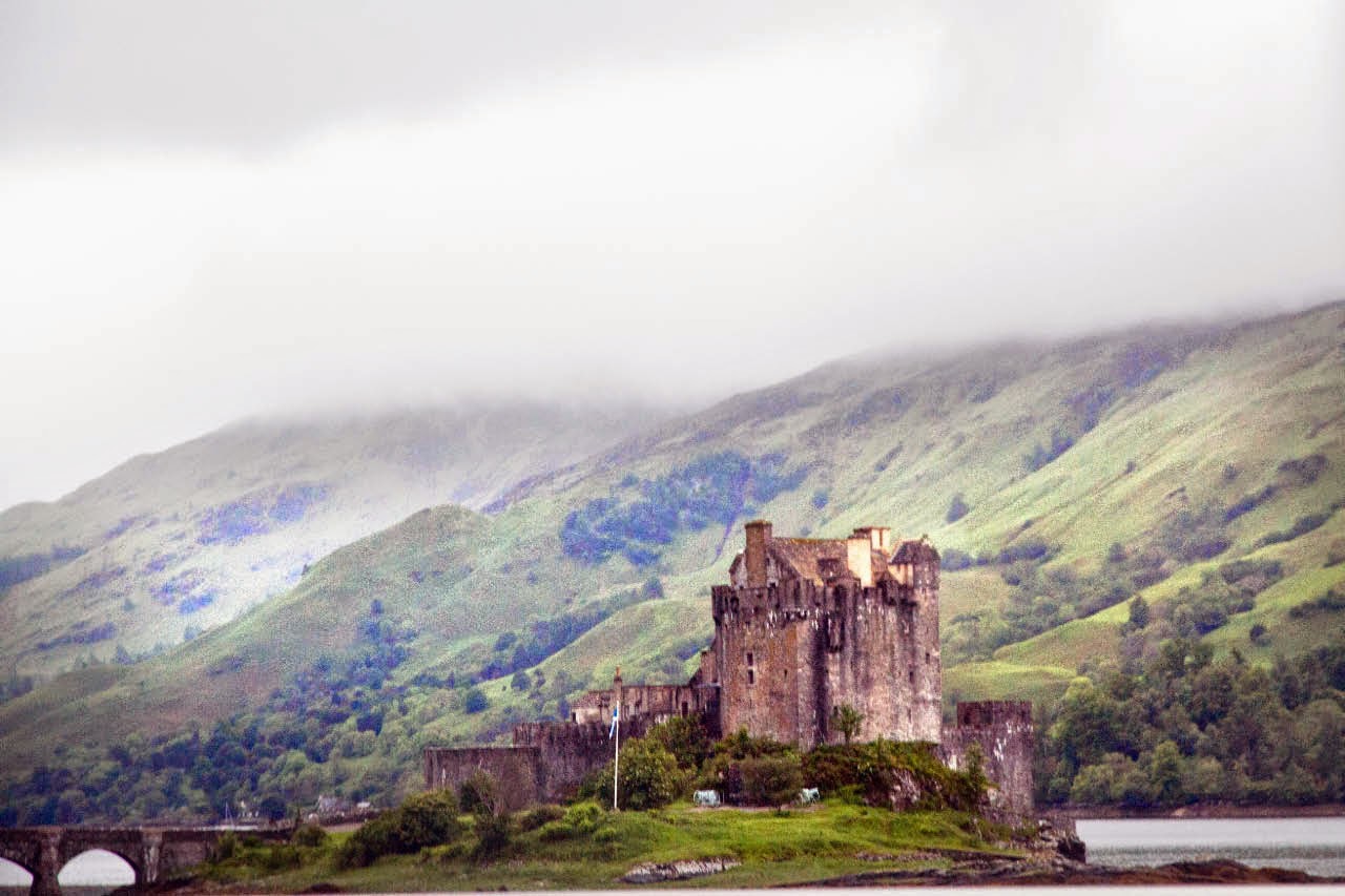


